“Visions of Empire” in London and Rome

‘What another city is to its own boundaries and territory, this city is to the boundaries and territory of the entire civilised world’ (quoted in Favro 2006).  These words, spoken by Greek orator Aelius Aristides in the first century AD, refer to Imperial Rome: the greatest and most powerful city of the classical Mediterranean world.  He refers to the ‘global’ reach of the Roman Empire; the city exerted influence in all corners of the civilised world.  Ancient Rome provides the ultimate model of an imperial city, and due to its profound effects on the cultural landscape of Western Europe, has become the benchmark of civilised imperial grandeur.  The Ancient Romans built their visions of empire into the urban and cultural fabric of their city, using imperial memories, display, icons, and spectacle to cement their ideals of the great imperial city into the built environment.  This then formed the blueprint for Rome’s reincarnations as centre of Christendom and the new visions of Mussolini’s Third Rome.  But Ancient Rome’s imperial model has also been imported to Western Europe’s greatest imperial city: 19th-20th Century London, at the zenith of imperial pride.  The authorities, planners and architects of London sought to create a capital fit for the largest empire the world has ever seen, and sought to create a British Rome, a worthy inheritor of the idealised imperial city of the past.  The parallels between imperial Rome and imperial London would be remarkable if it wasn’t for the fact that London was built as a conscious imitation; this was achieved, however, with a British spin to give London a unique imperial landscape compared to European rivals.

To the elites of Rome and London, the status of imperial power was the epitome of civilisation.  The Romans had brought culture and development to the barbarians of Europe and Africa through their superior military, political, cultural and intellectual might; it was the sign a society’s development and achievements.  The imperial nation thus represented the model of progress and modernity to the rest of the world.  This imperial vision was focussed in the imperial city: a showpiece of civilisation and superiority, designed to be an impressive beacon of superiority.  The imperial city should elevate the public to the status of enlightened conquerors, and impress the colonised with the permanence, order, and power of the imperial state.  These visions of empire are primarily held by the elite of society, and are translated to the public through the creation of a physical and cultural imperial landscape, conveyed not only through architecture, monuments and public space, but also through festivals, pageants, and imperial display.

Rome is a site of memory, in which past greatness can be remembered and represented; not just through the careful display of monuments and ruins in the recent past, but also in Imperial Rome, where the Golden Age of Augustus emphasised tradition and stability through preserving the rituals of the past.  The Augustan building boom, whilst impressive in scope, remained conservative in outlook; building design looked to past models of architecture rather than the creation of something new and innovative.  ‘The message was a vision of Rome’s past, a myth to reassure all about the transcendent greatness of Rome, and an image of Augustus himself as bringer of peace and prosperity’ (Stambaugh 1998).  However, the most concrete – and influential – expressions of imperial memory were in the reliving of past military triumphs through triumphal arches – structures whose only function was to glorify a particular military venture, and commemorate a great event.  The Arch of Titus, built just outside the Roman Forum, was built to commemorate the victories of Emperor Domitian’s brother; the Arch of Septimus Severus, built at the other end of the forum, was built to commemorate the victories of the emperor in the Parthian campaigns.  Such symbolic structures were purely for the glorification of imperial military prowess, and served as a constant reminder of the power of the state in the built environment.

SONY DSC
The Arch of Septimus Severus: an expression of imperial memory (Wikipedia Commons)

The memory of Imperial Rome was instrumental in the formulation of new imperial visions of Italy in the late 19th Century.  The monument to Vittorio Emmanuele II (the Vittoriano), built in 1911, was designed to manipulate public memory of Rome and past imperial greatness.  The classical style in burnished white stone emulates the classical past of the Roman Empire and the great monuments of the past civilisation; the sculptural figures on the façade represent the cities of Italy, depicted in the dress of the time of their greatest historical influence.  ‘The monument develops a heroic narrative of Italian history’ (Atkinson and Cosgrove 1998), emphasising past greatness and attempting to unify a newly created Italy through the memory of an ancient and glorious past.  The ruins themselves were excavated and cleaned by the new Fascist regime, attempting to ‘form the spectacular backdrop to the new monumental avenues constructed to stage the rituals and performances of Fascism’ (Atkinson and Cosgrove 1998).  The city was beautified and its remains were recreated as ‘works of art’, isolated from the fabric of the city; ‘cleaning up’ and repackaging the past (Agnew 1995) as part of a new imperial vision.

London attempted to portray itself as a direct inheritor of the status of Ancient Rome; the British Empire, too, was bringing light and civilisation to the barbarian lands of non-Europe, part of the westward march of progress.  In order to emphasise the past glories of Britain, new sites of imperial memory were created to celebrate British victories; Trafalgar Square pays homage to the pre-eminence of Britain’s role in battle, and Nelson’s column was once surrounded by statues of the military heroes Napier, Havelock and Gordon (Schneer 1999).  Nelson’s column itself was designed to resemble a column in the Temple of Mars the Avenger, a building of the Augustan era, whilst nearby Waterloo Place memorial was based on Trajan’s column.  The triumphal arches of Rome were also recreated – not to commemorate great battles, but simply to emphasise London’s connection to Rome’s imperial grandeur.

Classical architecture is the lingua franca of imperialism.  Its widespread use in the Roman Empire (reinterpreted from the Greek model) ensured that the ‘regular and orderly principles of classical architecture were seen to symbolise and reflect civilised values including order, economy, and secular probity’ (Bremner 2005).  Public and private buildings were designed in classical styles in line with these values – it became the dominant style of Whitehall and the City, two symbolic nodes of empire.  Soane’s design of the Bank of England was based on the Temple of Sybil in Tivoli; Bank Junction’s landscape of power is based on the stability, order, and splendour of Roman architecture.  The new India office portrayed a fictionalised memory of the British experience in India; Wyatt’s decoration of the façade  recasts the rather sporadic, opportunistic, and complicated manner in which the British amassed and ruled their Indian empire, conveying instead the image of a natural, even seamless rise to power all but complete in its illusion’ (Bremner 2005).  The parallels with the style of the Vittoriano monument, and the way in which the two buildings use architecture and sculpture to create a fictional memory of history, is evident.

Bank of England
Bank of England: the 1930s extension sitting on top of the Soane original. From Flickr

Imperial displays could be used to showcase power and progress; this could be through the design of buildings, layout of the city or displays of the colonies in temples, palaces, theatres and museums or through the creation of grand vistas, in both Ancient Rome and Imperial London.  In Ancient Rome, temples and palaces were status symbols built primarily to the glorification of a particular individual, such as the Forum Iulium built by Caesar, or Augustus’ Forum Augustum.  They are not thus strictly imperial; neither did the Roman’s have much of a concept of urban layout as a spectacle.  Emphasis on the cityscape or vista is a more modern idea, used by Mussolini in the new roads bulldozed through the medieval city to create grand new thoroughfares.  In London, the Mall was enlarged to become an imperial stage linking Trafalgar Square with the monarchy in Buckingham Palace.  This gave London a key new axis of power, creating a grand Haussmann-esque stage for imperial ceremonies.  The axis of Whitehall was connected to Trafalgar Square, a showcase of military power, which was connected via a distinctly Roman archway to the monarchical and ceremonial avenue of the Mall.  Westminster thus became a new stage for the display of imperial power.  However, neither Roman nor London authorities were ever able to create a grand Parisian-style master plan for their respective cities; Mussolini and London city planners were thwarted by complex property rights and conflicting interests, lacking an authoritarian emperor to force through changes in the cityscape.

Trafalgar_Square_360_Panorama_2
Trafalgar Square: the imperial pivot linking Buckingham Palace and Parliament (Wikipedia Commons)

The creation of imperial displays for consumption by the general public is unique to London.  In Ancient Rome, displays of war could often be displayed in temples; but in London, it was the museum that became the primary vehicle of imperial enlightenment.  In buildings such as the Imperial Institute, the empire could be displayed for the enlightenment of imperial citizens, educating them about their ‘brothers and sisters’ in the British overseas colonies.  South Kensington became a new educational landscape emphasising the civilisation of London: a new ‘imperial archive’ (Driver and Gilbert 1998), proving that knowledge equals power.  The empire could be consumed in different forms in the new department stores of Selfridges and Harrods, where imperial produce could be consumed in a self-consciously imperial setting.

These visions of empire were embodied in an urban landscape in a very physical way: in buildings, structures, and icons, creating a visual landscape of imperial values and spaces.  But through the use of the spectacle, the population of the city, as well as national and international visitors, could be united in imperial fervour and display, creating a civic enthusiasm for empire in patriotic cultural and mental landscapes.  The Romans are famous for their use of the spectacle; in gladiatorial battles, the exotic – often animals or foreign slaves – could be exhibited in an entertaining and blood thirsty fight to the death.  Military processions would celebrate victorious campaigns and display the spoils of war for the edification of the public.  In Mussolini’s Rome, fascist displays of power exploited the broad new avenues of the Via dei Fori Imperiali and the new Piazza Venezia in front of the Vittoriano monument.  Fascist displays utilised the ancient backdrop of the Forum, and the new imperial display of the Vittoriano monument as a stage set for the Third Rome, emphasising the historical continuity and glorious past and present of the Eternal City.

1024px-Piazza_Venezia_-_Il_Vittoriano
Mussolini’s Piazza Venezia (Wikipedia Commons)

In London, imperial display reached its greatest fervour in the many imperial exhibitions.  The Festival of Empire in the Crystal Palace in 1911 was a four day patriotic extravaganza: the Pageant of London, forming part of the celebrations, emphasised not just present imperial grandeur but the past glories of British history.  Pageants were ‘thought to be of educational value, instilling in participants and audiences alike a love of region, nation and empire’ (Ryan 1999).  Schneer (1999) describes in vivid detail the preparation that went into staging the return of the City Imperial Volunteers in 1900, on their way back from a successful campaign in South Africa.  The route of their procession was designed to go through all the imperial theatres in London, which could be seen to maximum advantage by the maximum number of people possible.  Displays and festivals such as these fostered a sense of national pride in the city and empire, recasting London as a giant imperial stage.

There are many visions of empire, just as there are many imperial cities.  This essay has focused on the visions of elites in building imperial capitals, creating imperial propaganda designed to enlighten citizens and impress visitors.  Ancient Rome has provided the benchmark in imperial values, and has been conceptualised ever since its collapse as a place of imperial enlightenment and a bastion of civilisation, in stark opposition to the barbarian Other that eventually brought the civilisation to its knees.  Rome’s subsequent development has been shaped by this memory, and utilised by the Papacy in the construction of new Classical churches and by later leaders reshaping Rome as an imperial European capital.  London was believed to be the direct inheritor of Ancient Roman values, and so their visions of empire closely match those of ancient planners and architects – although with time- and context-specific differences.  The imperial visions of military prowess, cultural enlightenment, civilisation, and progress were all fashioned in Ancient Rome; the first urban model for the rest of the world to emulate.  These ideas were translated to built and imagined landscapes through memorialisation of an idealised past, the use of imperial display, the use of architecture and sculpture, and through the use of spectacle to create a city worthy of empire.  In turn, this helped to create citizens who were worthy of the city: a city whose reach was designed to be felt by the entire civilised world.


Bibliography

Agnew, J. (1995) Rome (Chichester: Wiley)

Atkinson, D., Cosgrove, D. and Notaro, A. (1998) ‘Empire in modern Rome: shaping and remembering an imperial city, 1870-1911’, in Driver, D. and Gilbert, D. (eds.) Imperial Cities: Landscape, Display and Identity (Manchester University Press) 40-63

Atkinson, D. & Cosgove, D. (1998) ‘Urban rhetoric and embodied identities: city, nation and empire at the Vittorio Emanuele II Monument in Rome, 1870-1945’ Annals of the Association of American Geographers 88 28-49

Black, I. (1999) ‘Rebuilding “The Heart of the Empire”: bank headquarters in the City of London, 1919-1939’, in D. Arnold (ed.) The Metropolis and its Image: Constructing Identities for London, c.1750-1950 (Blackwell) 127-152

Bremner, G.A. (2005) ‘Nation and empire in the government architecture of mid-Victorian London:  the Foreign and India Offices’ The Historical Journal 48 703-742

Crinson, M. (1999) ‘Imperial story-lands:  architecture and display at the Imperial and Commonwealth Institutes’ Art History 22 99-123

Driver, F. & Gilbert, D. (eds) (1999) Imperial Cities: Landscape, Display and Identity (Manchester University Press)

Driver, F. & Gilbert, D. (1998) ‘Heart of empire?  Landscape, space and performance in imperial London’ Environment and Planning D: Society and Space 16 11-28

Favro, D. (1996) The Urban Image of Augustan Rome (Cambridge University Press)

Favro, D. (2006) ‘The iconicity of urban Rome’ Urban History 33 20-38

Gilbert, D. (1997) ‘London in all its glory:  imperial London in its guidebooks’ Journal of Historical Geography 25 279-297

Hetherington, P. (1994) Medieval Rome: A Portrait of the City and its Life (London: Rubicon)

Jacobs. J. (1996) Edge of Empire: Postcolonialism and the City (London: Routledge): esp. chapter 3

Krautheimer, R. (1980) Rome: Profile of a City 312-1308 (Princeton University Press)

Patterson, J. (1992) ‘The city of Rome: from Republic to Empire’ Journal of Roman Studies 82 186-215

Schneer, J. (1999) London 1900: The Imperial Metropolis (Yale University Press)

Stambaugh, J. (1988) The Ancient Roman City (Baltimore: Johns Hopkins University Press)

What can the UK learn from the practice of planning in other countries?

The UK was historically one of the first countries to attempt to control regional and urban development through town and country planning. With one of the largest empires of the time and extensive links with other European and North American countries, the UK has been a major contributor to the global development and practice of planning. Planning theories, ideas, practises and frameworks have been disseminated from the late 19th century to today through colonisation, modernisation and globalisation. The UK continues to be a major exponent of new ideas and practises, as well as receiving inspiration from other countries and cities; it can often be hard to tell exactly from where consensus has emerged. However, we should not ask “what” the UK can learn from elsewhere, but “how” and “why”? What does the idea of “best practice” mean, and how are some ideas translated across borders but not others?

Processes of spatial planning are grounded in a national and local political, legal and cultural framework. Practises vary between countries depending on the conception and definition of planning, their unique histories and geographies, and the relationship between the state and the individual. There is therefore no single definition of planning, and in order to review what countries can learn from one another, planning must be defined at a broader level. According to Healey (2011), planning as a process aims to shape urban and regional development pathways through deliberate and collective governance efforts. Within this broader context, there are a variety of different elements within spatial planning that can be translated across borders: techniques; principles; technologies; representations of urban form and urban design models; processes and ways of doing planning; policy instruments and regulatory mechanisms; and institutional frameworks (Healey and Upton, 2010). There are also different actors with roles to play in this dissemination: governments, aid organisations, design, planning and architectural consultancies, international organisations, think tanks and foundations, amongst others.

Planning ideas were first diffused through colonialism, with town and country planning as a field of government activity emerging in Western Europe and enforced on imperial subjects. Planning was conceived as a top-down, positivist and rational process, using procedural theory in policies such as zoning and the provision of large scale infrastructure. These ideas continued to percolate in the postcolonial era through the discourse of modernisation and modernism, when it was believed that all countries could achieve the same levels of development provided they follow similar trajectories and therefore utilised similar planning ideas. With postmodernism, planning has become more plural and diverse. The basic assumptions of planning have been questioned and replaced with recognition of situated contingencies. Although planning is now more plural and grounded in local contexts, ideas continue to spread through global economic integration and the commercial export of planning services (Healey and Upton, 2010): ideas as diverse as smart cities, participatory budgeting, green urbanism, and creative clusters have all become global objectives to be pursued in very different locations.

Tait and Jensen (2007) draw on Actor-Network Theory to explain how some ideas travel. The transmission of an idea depends on the strength of network in which it is embedded. The influence and networks of the human actors; the strength of the imagery and texts used; the ubiquity of the problem being solved; and the strength with which these elements are able to cohere and coordinate, are all critical in the transmission of certain ideas. A project grounded in a particular political-economic and cultural context, designed to meet specific local needs, can become a symbol of a new approach and offer hope to policy makers grappling with similar problems or operating under similar ideologies. The idea could then transmit around the world, often becoming divorced of its location and losing its original aims and focus. Howard’s Garden City ideal could be one example.  The powerful imagery and language of the original idea, the involvement of powerful backers with a new society and journal, and the consensus of policy makers allowed to idea to become globally transmitted – although divorced of Howard’s original radical objectives.

Cover_of_Garden_Cities_of_To-morrow

According to Healey (2011) restless policy could cause real harm: there may be problems in its implementation; the real nature of the problems to be solved may go unnoticed; the policy could be captured by powerful or vocal interests; and local people could see themselves as powerless to affect policy. The lessons of modernism shows that one-size-fits-all policy rarely works in the ways desired. Watson (2012) warns that much planning theory continues to emerge from the cities of the Global North, ignoring the “stubborn realities” of urban life in the South – where a stable, liberal and democratic state and independent property rights are not always present. However, this should not mean that each country has to “reinvent the wheel” when it comes to planning – there may be certain universal values that can be captured, distilled and reinterpreted (Healey 2011).

The UK is therefore in a position to learn much from other countries. Different practises, frameworks, ideas and theories are continually entering the debate at a variety of scales and through a variety of actors. Tait and Jensen (2007) use the example of Business Improvement Districts, an idea originating in North America, but successfully transplanted to the UK despite different urban contexts and needs. The model appeals to powerful multinational businesses, offering greater control in the management of particular urban areas and enabling them to attract mobile people and capital; it also appeals to governments, who can outsource certain functions to BIDs and achieve neoliberal and entrepreneurial objectives of streamlining operations and facilitating private sector activity. BIDs arose in a particular context, became globalised, and can now be easily manipulated and standardised to different countries – Tait and Jensen write the UK BIDs are likely to take quite a different trajectory to North American ones due to different institutional frameworks.

Another recent example could be cycling policy. Improving cycling culture has become a powerful urban objective in the past decade; improving the provisions for bicycles and increasing its modal share of transport has widely recognised benefits for the environment, health, and traffic management. One particular angle of this is the bicycle share scheme. Although cycle hire schemes had been tried in Amsterdam and Copenhagen in the 1960s and 1980s, it was the “third generation” cycle schemes emerging in Rennes and Lyon that caught global attention. The schemes were popular with residents; they helped to meet goals of improving sustainable mobility; and it was done at little cost to the taxpayer, thus achieving environmental and neoliberal goals. The number of countries with cycle sharing programmes has swelled from ten in 2002 to nearly 50 in 2013, covering over 500 cities[1]. These range from modest schemes of a few tens of bikes to 90,000 shared bicycles in Wuhan, China. The strength of the idea is its flexibility, with sponsorship deals, tariffs, and technologies adapted between different cities.

Plans were first unveiled for London in 2008, but it wasn’t until 2010 that the Barclays Cycle Hire scheme was officially launched, with 5000 bikes at 315 docking stations. Although this idea has not yet percolated to the rest of the UK, the London scheme has proved popular; there are now 10,000 public bicycles in the capital. The cycle scheme forms a key pillar of the Mayor’s vision to increase the modal share of cycling from two to five per cent of London’s traffic in 2026. This has had major implications for planning in the capital, with Transport for London engaging in major improvements to cycling infrastructure and coordinating the different transportation schemes. In addition, Transport for London still subsidises the cycle scheme with around £11 million per annum, with private sponsorship from Barclays amounting to £25 million over five years[2].

1280px-Barclays_Cycle_Hire,_St._Mary_Axe,_Aldgate

Planning practises have been shared globally since the invention of planning as a governmental activity, with the UK playing a key role in this dissemination. Since the 1980s, ideas of what planning is and how it should be done have proliferated, with the recognition that policies should be innovative and grounded in local contexts. Planning is now pluralist and post-positivist. However, globalising cultural tastes and forces of economic integration have continued to create powerful narratives of what planning should be, what objectives it should have and how it should operate. Agendas, tools and frameworks have continued to globalise. The UK is still both an exporter and recipient of planning ideas, with much to learn from examples in other countries. However, these ideas must not be tested blindly or foisted on unwilling populations; as Healey points out, transnational learning will be most efficient and productive if ideas are packaged with their origin stories and narratives and can retain their radical edge.


Bibliography

Healey, P (2011) The universal and the contingent: some reflections on the transnational flow of planning ideas and practises, Planning Theory 11(2) 188-207

Healey, P & R Upton (2010) Crossing borders: international exchange and planning practises, Routledge, London

Healey, P (2013) Circuits of knowledge and techniques: the transnational flow of planning ideas and practises, International Journal of Urban and Regional Research, 37(5) 1510-26

Tait, M and OB Jensen (2007) Travelling ideas, power and place: the cases of Urban Villages and Business Improvement Districts, International Planning Studies 12:2, 107-128

Transport Canada (2009) Bike-Sharing Guide, http://www.tc.gc.ca/media/documents/programs/bsg.pdf

Watson, V (2012) Planning and the “stubborn realities” of global south-east cities: some emerging ideas, Planning Theory 12(1) 81-100

[1] http://www.earth-policy.org/plan_b_updates/2013/update112

[2] http://www.dailymail.co.uk/news/article-2359258/Londons-4-000-Boris-bikes-cost-taxpayers-1-400-bicycle-year-despite-sponsorship-Barclays.html

Does planning inhibit economic development?

In his second speech as Chancellor of the UK, George Osbourne stated: “we are going to tackle what every government has identified as a chronic obstacle to economic growth in Britain, and no government has done anything about: the planning system. …Cumbersome planning rules and bad regulation stand in the way of new jobs.”[1] The Royal Town Planning Association responded that this and other ministerial statements were part of an “ill-informed attack on planning and an attempt to make media headlines”[2]. Planning is an intrinsically political and inherently contentious issue, with vociferous debates such as this casting the planning process as either a growth-stifling bureaucratic monster, or an essential democratic process to safeguard the community’s best interests. Whilst no one is suggesting that planning should be abolished entirely, the interaction of planning with economic growth is a contentious issue, particularly in the context of recession. The UK government has argued that job creation and business expansion were more important than jumping through multiple costly hoops to obtain planning permission, and has embarked on a “bonfire of red tape” with the aim of promoting growth. This is an issue that this essay seeks to further investigate.

According to Rydin (2011 p7), “Planning has arisen in response to political pressure over the opportunities, losses and inequalities associated with urban change.” Almost every aspect of our environment, particularly in highly urbanised Western Europe, is managed and developed by human activity. Planning is a broad field, encompassing all activities that help to create the kinds of places where people want to live, work and invest – helping places to function better socially, economically and environmentally (Adams and Watkins 2014). Planning, then, is essential is ensuring equitable and integrated development: development that fulfils the needs of all members of society.

In the UK, planning is a discretionary system, where each development application is assessed based on its own merits and context; this involves a heavy reliance on case law in the interpretation of policy. Under the Coalition Government, planning reforms have condensed the amount of national policy from around 1,000 pages to 65, published as the new National Planning Policy Framework in March 2012. Local development plans are now the focus of the English planning system, with local authorities determining land use plans in consultation with stakeholders; the resulting plans become the basis for determining planning applications.

In making these reforms, attention was focused on the overbearing, prescriptive and bureaucratic nature of the English planning system, which was believed to significantly increase the costs of applications in terms of time and money. According to RTPI[3], some government ministers have in the past opined that the UK planning system is the most costly in the world – a view that continues to resurface amongst different commentators. This could be through the costs of running planning departments (burdening the tax payer); and costs to businesses, both in application fees and through the inevitable delays in waiting for permission. More broadly, planning is responsible for allocating the supply of land available for different uses: under the laws of supply and demand, constraints will push up the price of land relative to a situation without regulation (all other things being equal). This can then push up the prices of goods which use land as an input, such as housing. This will then affect consumer choices, which affects the locations of productive activities and households. Over-regulation might therefore mean that planning stands as a barrier to growth: limiting the supply of land, imposing conditions that increase the cost of development, and raising prices of consumer goods (Vivid Economics 2012).

Under classical economic theory, it might be argued that through the “invisible hand” of market forces, individuals acting in their own self-interests will also act in the interests of society as a whole. Thus, under only the lightest of guidance and regulation, businesses and individuals could be trusted to invest and develop in ways that would benefit society as a whole – lighter regulation allowing faster growth. If a business wishes to build a new factory, for instance, under conditions of recovery from recession this should be expedited in order to secure jobs for the local community and faster recovery. For instance, in June 2014 the Secretary of State for the Environment, Eric Pickles, gave permission for the expansion of Pinewood Film Studios in Buckinghamshire, despite its location within the greenbelt surrounding London. Here, the importance of the scheme to jobs in the UK film industry was deemed more important than the restrictive rules regarding greenbelts. However, it was made clear that these were “exceptional circumstances” and should not be used as a precedent (Dunton 2014).

As pointed out by Vivid Economics (2012) and Adams and Watkins (2014), such a reductive view of planning does a disservice to the wider value that planning brings. In safeguarding ecosystems, promoting sustainable development, and ensuring that all members of the population have equitable access to economic opportunities, planning plays a vital role in safeguarding our social, cultural, environmental and economic lives. Planning systems are designed to ensure the “greater good” of society, enshrining in law a longer-term vision that seeks to avoid a tragedy of the commons – for instance by limiting pollution, promoting green transport, and listening to the concerns of communities. Not all of these services have a definable economic value, but shaping places and therefore markets is capable of breeding confidence, reducing risk and transforming developers’ attitudes and behaviour.

Part of the UK government’s ‘bonfire of the red tape’ was the abolition of Regional Spatial Strategies in 2010. These regional strategies, formally begun in 2004 by the Labour government, were set out by central government based on the advice of local authorities. They were designed to ensure that things such as housing needs could be set out at a regional level, with local authorities working together to best place them. However, the new government of 2010 saw them as an unnecessary layer of bureaucracy, enforcing targets in a top down manner on local people. With abolition, more power is now devolved to local areas, enabling them to set their own strategic priorities and give local people more of a say in development (Boddy and Hickman, 2013 p745).

Boddy and Hickman (2013) have investigated how this plays out in the prosperous Greater Bristol region, in the south west of England. In the four unitary authorities that made up the region, “Targets for housing numbers… were significantly reduced in comparison with the RSS [Regional Spatial Strategy] and proposed major urban extensions were taken out of the equation” (ibid, p760). The reduced housing numbers were justified in the context of recession and depressed demand, but the authors point out that local communities are generally opposed to local development, and that the new localism framework was a “charter for NIMBYism”. The Regional Spatial Strategies were vehicles for neoliberalism, legitimising economic competitiveness and growth; their abolition gave way to short-termism and selfishness. They conclude that “It is very difficult to see how a narrative of economic growth can now be effectively constructed on the ground in the context of localism” (ibid, p765).

This illustrates the central concern of planning. By abolishing the middle tier of strategic thinking, local authorities were given more control over setting their own development targets; in the wealthy south west, with huge pressure for development, this actually meant a reduction in targets and a sacrifice of long term vision. In this case then, it can be argued that planning does not hinder economic development: instead, quite the reverse. A lack of planning inhibits economic development: empowering local communities runs the risk of unleashing NIMBYism, and therefore stalling growth.

Planning is vital in ensuring that the UK remains an attractive and sustainable place to live. In such a democratic process, it is inevitable that there are trade-offs: every development has winners and losers. This makes planning a contentious, and fascinating, issue. Whilst abolishing unnecessary bureaucracy and making planning more accessible is laudable, the government must ensure that local people and politicians are able to plan in a sustainable and long-term way, to ensure economic growth not just tomorrow, but for years to come.


References

Adams, D and C Watkins (2014) The Value of Planning, RTPI Research Report no.5, June 2014

Boddy, M & H Hickman (2013) The demise of strategic planning? The impact of the abolition of Regional Spatial Strategy in a growth region, Town Planning Review, Vol. 84: 6, p743-768

Dunton, J (27th June 2014) Economic case trumps green belt harm, Planning Resource http://www.planningresource.co.uk/article/1300877/economic-case-trumps-green-belt-harm

Healey, P (2010) Making better places: the planning project in the 21st Century, Palgrave Macmillan Basingstoke

Rydin, Y (2011) The Purpose of Planning, Policy Press Bristol

Vivid Economics (February 2012) Inexpensive Progress? A framework for assessing the costs and benefits of planning reform, prepared for the Campaign to Protect Rural England, National Trust and Royal Society for the Protection of Birds

[1] http://www.telegraph.co.uk/finance/budget/8401022/Budget-2011-Chancellor-George-Osbornes-speech-in-full.html

[2] http://www.rtpi.org.uk/media/7353/RTPI-Budget-Briefing-2011.pdf

[3] http://www.rtpi.org.uk/knowledge/core-issues/planning-myths/myth-number-3-planning-is-costly/

Types of Planning Work

In addition to providing general advice on planning (for instance, through a formal appraisal), the following are formal aspects of planning consultancy work. All will require some form of interaction with the Local Planning Authority.

  1. Permitted Development: permission is not normally needed. Consultants wouldn’t get involved except to advise on grey areas, which may require informal negotiation with the Local Planning Authority.
  2. Prior Approval: development is okay in principle but paperwork is needed to clear it with the Local Authority (usually information on access/highways; contamination; and flood risk)
  3. Planning Application – many different types of varying scales.
  4. Listed Building Consent – for works to a Listed Building. This can usually be dealt with by architects, but if it will impact on a wider area then we can become involved.
  5. Conservation Area Consent – for any work in a conservation area (this is usually as a precaution against demolition/work to a non-Listed Building)
  6. Advertisement Consent Application – for adverts that can’t be considered permitted development by virtue of size, positioning, design, location, lighting, etc.
  7. Planning Appeal – for non-determination of an application, or appealing against a refusal. This is taken up by the Planning Inspectorate.
  8. Conditions Discharge – conditions can be prior to commencement of development; prior to occupation of development; or on completion. We would most often get involved in the prior-to-commencement, which are most often providing additional surveys (particularly archaeology or ecology).
  9. Enforcement Action – when something has been done in breach of planning/building control and a response from the owner/occupier is required. This can be formal (through an Enforcement Notice) or informal (through a Planning Contravention Notice).
  10. Enforcement Appeals – if you think something has been enforced against wrongly (for instance it counts as permitted development).
  11. Objections – on behalf of a 3rd party against a live planning application. Must be done within the consultation window.
  12. Certificate of Lawful Existing Use or Development (CLEUDs) – to demonstrate that an existing use/development is/has become lawful, usually through the passage of time.
  13. Certificate of Lawful Proposed Development (CLOPDs) – not very common, but to demonstrate that work you are about to do does not require planning permission.
  14. Site promotion – promoting a specific site for development allocation in an evolving Local Plan.
  15. Local Plan representation – commenting on draft local plan policies or site allocations on behalf of third parties.

Tree Surveys

autumn_trees_in_dresdenTree surveys are often required for planning, where trees may/will be affected by development.

Start with a topographic survey, which records tree locations and canopy sizes. The arboricultural surveyor then plots the trees: they measure the stems and branches to determine age and canopy size, and then categorise.

A – these are the best trees, the most ecologically valuable or important to the character of the area. They should be retained.

B – good quality trees that should be avoided if possible.

C – these are smaller, younger and less healthy trees.

U – unsuitable for retention (small, young, diseased, overcrowded)

If anything is to be removed, it usually has to be replanted on a 1:1 basis.

This results in a Tree Constraints Plan.

Tree Protection Plan: this is based on root area. The trees to be kept are given a Root Protection Zone, which needs to be avoided during development. The roots could potentially be damaged through severance, soil compaction, and loss of air/water. Ways to avoid the protection zone could be:

  • No dig zones, which are securely fenced off;
  • Use of permeable roads/surfaces;
  • Hand dig drenches, or use an air spade to avoid compaction and severance of roots;
  • Use mini-piles for foundations (usually a last resort)

Remaking Paris: Le Corbusier, Guy Debord, and Planning Theory

The city has a vital role in the history of human civilisation. Cities are physical expressions of trade, commerce, consumption, warfare and migration, produced by political and cultural forces. In turn, cities shape human culture and understanding. The built environment is a concrete manifestation of ideas of how society was, is, and how it should be: a representation of ideas about how humans should live. Planning theories have built upon successive representations of idealised urban life, with some representations becoming codified into planning practice and shaping the way cities are built. This essay will focus on two twentieth century representations, which I use to loosely symbolise aspects of modern and postmodern planning theories: the first, Le Corbusier’s “la Ville Radieuse” of 1933; the second, Guy Debord’s “Guide Psychogeographique de Paris” of 1957. These are two diagrammatic urban models that went on to shape the rational modernist city, and the city of experience and spectacle.

Le Corbusier is perhaps the most divisive of all urban planners. Whilst spectacularly unsuccessful in terms of built output during his lifetime, he is an influential figure in modernist planning theory and practice and a titan of the twentieth century. He was born in Switzerland in 1885 and moved to Paris in 1916, characterised by Hall as a city of “exuberant, chaotic, often sordid everyday life” (2002, p222). Corbusier sympathised with the “strong men” that had attempted to reorder and rationalise Paris, but believed their work to be unfinished – interwar Paris was a place wracked with slums and disease. Paris, and cities like it, could only be saved by a similarly spectacular and authoritarian intervention that could reorder urban life and human society along rational, technological and industrialised lines.

Corbusier believed that modern architecture should reflect the technological progress of the modern era, with the home distilled to its bare components and mass produced using industrial techniques as a “machine for living in”. These ideas were developed and extended for grandiose urban planning, embodied in the influential La Ville Radieuse in 1933. The diagram shows a city sanitised into constituent parts: industry in the south, housing in the centre, and business and government to the north – everything constructed in grids and bisected by radial avenues. The key was to open up city centres to light, air and greenery in order to improve health and transit, which could be done through building superblocks interspersed with greenery – towers in a park. “The city of today is dying because it is not constructed geometrically” (Le Corbusier, 1929 in Hall, 2002 p223); meaning that the city of today could only be remade through wholescale demolition of what had come before.

This representation of the ideal society required the absolute authority and control of the city planner: “The harmonious city must first be planned by experts who understand the science of urbanism. They work out their plans in total freedom from partisan pressures and special interests; once their plans are formulated, they must be implemented without opposition” (Le Corbusier, 1929 in Hall 2002 p225). The primacy of the plan, the importance of the scientific and technological method, and the authority of the planner were central tenets of modernist planning theory, and had major influences upon the systems and rational theories of the 1960s and 70s. Neither systems theory nor rational theory saw planning as completely static, and sought to move away from operating in a “blank canvas”. Both sought a greater understanding of human behaviour than Corbusier had ever attempted. But both theories shared with Corbusier a belief in planning as a top-down, technical and apolitical process, underwritten by universal rules (Allmendinger 2009).

20ville_radieuse.jpg
La Ville Radieuse – from Arch Daily

In 1957, French theorist Guy Debord published a very different representation of the city. His “Psychogeographique de Paris” portrayed a broken up map of Paris, fragments of neighbourhoods stuck on paper and linked by hand drawn arrows, representing the drift of an observer through the atmospheres and emotions of the city. This was a wholehearted rejection of Corbusier’s city-as-machine, remaking Paris as a chaotic kaleidoscope of experience and spectacle. Debord described psychogeography as the “study of the precise laws and specific effects of the geographic environment, consciously organised or not, on the emotions and behaviour of individuals” (1981, in Pinder 2009 p597). Psychogeography emerged as a way of thinking about space in terms of experience, and aimed to challenge dominant representations and practises in fields such as cartography and planning. This suggested that the city is created not just by architects and planners, but by the sum of individual experience and meaning: to encounter the city was to create the city (Grant 2012).

Debord was a founding member of the Situationist International, a group of radical scholars, architects and artists, active in Western Europe in the 1950s and 60s. With roots in Marxism and surrealism, they attacked capitalism and modernism as producing alienation and commoditising everyday life. They encouraged attacks on and revolts against hierarchical power, and cities in particular were understood as key sites of both oppression and potential freedom. Out of this movement grew psychogeography, attempting to counter the soullessness of capitalism through play and experiment. Debord’s map of Paris used these ideas to create a new geography of the city, based on play and experience rather than rationality and straight lines.

This in turn influenced an analytical strain of urban design, spearheaded by Kevin Lynch and his development of cognitive mapping. In his book The Image of the City (1959, p1) Lynch wrote: “At every instant, there is more than the eye can see, more than the ear can hear, a setting or a view waiting to be explored. Nothing is experienced by itself, but always in relation to its surroundings, the sequences of events leading up to it, the memory of past experiences. …Every citizen has had long associations with some part of his city, and his image is soaked in memories and meanings.” Lynch sought to understand these meanings and memories and feed them into urban design and city planning, creating places that were more vivid and memorable – places that crafted experiences.

debord-guide1.jpg
Debord’s map of Paris – from Mapping Weird Stuff

This was part of a movement encouraging the rejection of top-down, authoritarian planning theories, towards more of an advocacy and collaborative approach. Insofar as postmodernism presents a rejection of over-arching narratives and scientific rationality in favour of flexibility and fragmentation, this could be characterised as part of the postmodern movement in planning theory. Postmodernism’s concerns with social justice and community would have been recognised by the radicals of the Situationist movement; Kevin Lynch thought it important to engage in a dialogue with residents on how they saw the city, which could develop into a dialogue on how they wanted it to change. Lynch’s concerns with city imageability and legibility also played a major role in the neoliberal makeovers of many city centres.

The diagrams of Le Corbusier may have had little direct impact during his lifetime, but came to epitomise the modernist approach to planning. This influence can be seen most clearly in post-war housing estates and the highways that came to dominate city downtowns. The importance Corbusier placed on top-down, scientific planning influenced the systems and rational theories of planning. The Situationists rejected any need for urban planning, but Debord’s unusual map of Paris alongside shifts in urban design encouraged planners to move in a postmodern theoretical direction, considering the political nature of planning and calling for a more inclusive and bottom-up approach. On the ground, this can be seen in community projects and social movements, dovetailing into demands for urban spectacles and events – planning that takes into consideration memory and experience, but planning that is arguably more neoliberal in its theoretical approach.

There are certain diagrams and representations of space that have had the power to shape our ideas of how cities should look. These have become theories-in-planning, calling for straight lines or urban experiences, which have in turn informed theories-of-planning: planning as a rational activity or planning as de-centred and bottom-up. Planning theories envision new ways to create the environment, and remake society. These two representations distil and clarify complex ideas of how cities might look; how planning might function; and how society should be.

References

Allmendinger, P (2009) Planning Theory, Palgrave MacMillan

Grant, B (2012) Grand Reductions: 10 diagrams that changed city planning, The Urbanist, Issue 518, November 9th 2012 http://www.spur.org/publications/article/2012-11-09/grand-reductions-10-diagrams-changed-city-planning

Hall, P (2002) The City of Tomorrow, Third Edition, Blackwell

Lynch, K (1960) The Image of the City, MIT Press

Pinder, D (2009) Psychogeography, in Gregory, D, R Johnston, G Pratt, M Watts and S Whatmore Dictionary of Human Geography, 5th Edition, Wiley-Blackwell

The “South Seas Island Paradise” in 19th Century Western Geographical Imagination

paradise

I thought I was transported into the garden of Eden’, wrote Pierre de Bougainville in April 1768.  ‘A numerous people there enjoy the blessings which nature showers liberally down upon them… One would think himself in the Elysian fields’ (after Bayliss Smith, 2011).

In ‘discovering’ the Pacific island of Tahiti, the French sea captain clearly thought he had found Arcadia: imagery from both Genesis and Hesiod were employed to situate this island in Western historical and geographic imagination, depicting Nouvelle-Cythère, or Tahiti, as an earthly paradise.

The Pacific Ocean represents 27% of the Earth’s landmass.  The islands are pinpricks in a vast sea, covering an area the size of England.  Eighteenth Century explorers would sail for weeks without sight of land; it is no wonder that the appearance of a shimmering island on the horizon, floating on turquoise waters, would excite their imagination and inspire glowing reports of discovery.  The sight of beautiful women beckoning them to shore seemed a mirage, a miracle of deliverance.  As Bougainville wrote, ‘It was very difficult, amidst such a sight, to keep at their work four hundred young French sailors, who had seen no women for six months…’ (after Bayliss Smith 2011).


The literary and artistic accounts that depicted these islands to Europeans for the first time did not present a picture that was unambiguously Elysian, but did tend to emphasise its idyllic qualities, particularly the noble character of the inhabitants and the benevolence of the natural world.  The French accounts of Bougainville and his naturalist Commerson portrayed an island that could best be understood in Classical terms.  The islanders displayed the noble characteristics and physical beauty of the Ancient Greeks; their friendliness and generosity seemed to echo the natural environment that they inhabited.

Similarly, the artists on Captain James Cook’s voyages used Classical and Biblical frames of reference to represent and understand the South Pacific.  The work of painter William Hodges presented an exotic ‘other’, an exciting and enticing island world that nevertheless remained safely situated within European ontology and artistic tradition, and could thus be ‘known’.

Map 1589.jpg
The Pacific in 1589

The belief in the earthly paradise stems from centuries of Western intellectual philosophy.  Medieval scholars had long sought to pinpoint the geographic location of the Garden of Eden, and whilst the Enlightenment and rise of humanism somewhat diminished the intellectual currency of the existence of a physical garden, the idea of paradise as a garden remained culturally embedded.  The islands of the Pacific were geographically and imaginatively poles apart from the European continent.  The Pacific was everything Europe wasn’t, whilst the inhabitants seemed to live in simplicity and harmony with the natural world.  The Pacific, and Tahiti in particular, showed the Europeans an image of themselves before the onset of civilisation, hearkening back to the Golden Age of the Greeks or the Eden of the Bible.

However, prolonged contact with island societies revealed a different reality.  Not every island was a paradise – Bougainville also discovered and named an Ile des Lepraux, the antithesis of Arcadian Tahiti.  The people were disagreeable and unfriendly, their bodies black and diseased; warfare, hostility and an inimical climate symbolised savagery, brutality and ugliness.

The problematic of friendly and ugly islands was set out by d’Urville in 1832, who divided the multitudinous islands into Micronesia, Melanesia and Polynesia as a way of explaining difference.  Polynesia was more advanced, the people more European and beautiful; the Melanesians were negroid, savage, and cannibalistic (Thomas 1989; Connell 2003).  Polynesia could therefore continue to be the distant Aryan cousin to Europe, while Melanesia became home to an essentialised and totalistic ignoble savage.  It was a division between paradise gained and paradise lost, and the fantasy of a mythical South Pacific existing in a timeless Golden Age could be maintained through the binary of Polynesia/Melanesia.

However, empirical experience soon gave rise to conflicting ideas of Polynesia’s paradisaical status.   The Polynesians had flaws, just like any human society: lice, cross-dressing, homosexuality, infanticide, and even bestiality (Daws 1980).  Warfare, sacrifice and cannibalism were a fact of life.  In 1779, Cook was killed in Hawaii; his death was quickly mythologised as symbolic of the Pacific’s Original Sin (Edmond 1997) – he was beatified by the British public as the benevolent bringer of civilisation cut down by savages.  His death represented a fall from grace.

Yet Cook’s third voyage had been beset with controversies from the start; his crew were surprised at his fits of temper and the aggressive overtones of his interaction with the indigenous community.  Smith (1992) hypothesises that Cook was becoming increasingly disillusioned with the already observable impacts of contact with island societies.  Paradise was already being despoiled by the Europeans, inspiring a nostalgic regret for the lost beauty of Pacific society (Connell 2003).

explorers-2
HMS Resolution and HMS Adventure in Matavi Bay, Tahiti – William Hodges

Some Europeans argued that the South Pacific could never be a heavenly paradise if it was inhabited by devil-worshippers.  The empirical reality of human sacrifice, monstrous idols, cannibalism and heathen rituals raised outrage and horror in Europe. Depictions of savage activities formed new imagined geographies of danger and savagery: paintings such as Webber’s ‘A Human Sacrifice in Tahiti’ (1784) became widely reproduced and disseminated. In its various reworkings, Tahitians were depicted as squat, swarthy and uncivilised, lacking any personal dignity (Smith 1985).  Natives were awaiting civilisation, and it was the duty of Europeans (principally the British) to rescue them.  Any resistance merely proved their savagery.  Unredeemed natives were not noble, but objects of pity, dislike or fear.

In 1795 the newly formed London Missionary Society chose Tahiti to be its first field of operation.  In their naïve idealisation of the Pacific, the only perceived difficulties for the Missionaries would be the fascination of beauty and seduction of appetite (Edmond 1997:98).  This was an alternative fantasy of the Pacific as a Christian Arcadia in a re-creation of the Garden of Eden.  However, the early years of missionary activity were disastrous.  Elsewhere, missionary activity could be exceedingly dangerous – the Reverend John Williams was infamously killed and eaten in Vanuatu in 1839.

But despite empirical reality, the island of fantasy continued to live on in art and literature.  The isolation of the island provided an idealised space for self-definition, a blank slate onto which your own fantasies and fears could be projected.  This was the setting for Robinson Crusoe, Coral Island, or Treasure Island – classic books using the island setting to explore key themes of Romanticism, colonialism, and civilisation.  Robinson Crusoe, although published before the discovery of the Pacific, was reimagined in a South Sea setting: the cannibals, sun, and benevolent nature all foundational tropes of the nonspecific Pacific island.  Robinsonades borrowed the masculine imperialist ideas of Defoe to narrate the inevitable spread of European enlightenment.  Pacific Islands were fantasised not only as paradises, but as blank slates, ripe for colonialism and civilisation – even if colonisation was to be only symbolic.

As a site of struggle for the self, islands could also unleash something more dangerous and bestial in human nature.  Islands were places of confusion and ambiguity: paradises inhabited by savages, cannibalistic religions practised in sunny valleys and lush forests, coconut groves guarded by horrible idols.  They were spaces to discover your capacities in reconstructing the Western model of society in an island setting – themes beloved of boy’s adventure stories throughout the nineteenth century.  Robinson Crusoe successfully civilised his island, but elsewhere the struggle of Man and Nature, Enlightenment and Savagery, could come to a different conclusion.  The Mutiny on the Bounty captured Romantic imagination at the end of 1700s: sailors rising up to overthrow authority, casting off the Rousseauesque shackles of civilisation in favour of a life of pleasure and simplicity in paradise.  Yet the mutineers found that paradise unleashed their inner savage: struggles for dominance in a society lacking boundaries and authority led to a sustained bloodbath on the Pitcairn Islands.  There could be no better demonstration of the importance of the values of civilisation in restraining barbarity.

Zoffany_Death_of_Captain_Cook.jpg
The death of Captain Cook – Johann Zoffany

After a century of colonial rule the islands of the Pacific were very different places to those discovered by Bougainville and Cook.  But their isolation remained alluring to those who wished to escape.  Paul Gauguin arrived in Tahiti in 1891, seeking his inner savage and looking to find a missing corner of his self (Daws 1980).

He described his first sighting in almost Biblical terms: ‘It is the summit of a mountain submerged at the time of one of the ancient deluges.  Only the very point rose above the waters.  A family fled thither and founded a new race – and then the corals climbed up along it, surrounding the peak, and in the course of centuries builded a new land’ (Gauguin, 1985:1).  This ahistorical depiction of Tahiti ignores the impact of decades of colonialism, and Gauguin populates his imagined island with an isolated and ancient race of people who had been there since Noah’s Flood.

Gaugin sought decolonisation, finding in Tahiti everything that was missing in France: sexual openness, honesty, simplicity and freedom.  The Tahiti of his imagination was very different to the Tahiti of reality – an island decimated by sexual disease, colonised by missionaries and the French state, a dusty and ordinary outpost of the French Empire.  In his imagination it was transformed into a land of colour, sexual opportunity, mysticism, and a cosmology very different to anything he had experienced.  Yet his fantasy of being a sexually liberated artist living in sunny simplicity was confounded by reality – shunned by his Catholic missionary neighbours, cuckolded by his teenage sexual partners, dying of syphilis, a pauper and by his own reckoning, a failure.  His ambiguous relationship with Tahiti and the Marquesas perhaps typifies nineteenth century attitudes to the South Pacific.

gaugin

The South Sea Islands seemed worthy of Homeric myth to the sunburnt sailors that discovered them.  Experience soon proved that they were far from Arcadian, and the people by no means were lost Greeks.  Despite the initial enthusiasm, ideas of the Pacific became more complex and contested almost immediately; empirical reality proved that they were ambiguous spaces of savagery and barbarism, into which Westerner’s own fears and fantasies could be projected.  The islands of the Pacific could be spaces to find yourself; spaces awaiting the Gospel and civilisation; spaces to colonise and conquer; spaces in which you could be decolonised.  But the ideal of paradise remained hovering overhead throughout as a model to strive towards – a Christian utopia, a place of freedom, a place of sexual opportunity, a place of bounteous nature, something that could be continually sought but never quite found.  These visions were never quite the reality; but the trope remains.  Paradise was never banished from nineteenth century imagination; the reality was infinitely more complex and ambiguous.

Bibliography

Connell, J. (2003) Island dreaming: the contemplation of Polynesian paradise, Journal of Historical Geography 29(4)

Daws, G (1980) – A Dream of Islands: Voyages of Self-Discovery in the South Seas, WW Norton & Co, London

Edmond, R (1997) – Representing the South Pacific: colonial discourse from Cook to Gauguin, CUP: Cambridge

Gauguin, P (1985) – Noa Noa, Dover Publications

Phillips. R (1997) – Mapping Men and Empire: a Geography of Adventure, Routledge: London

Spate, OHK (1988) – Paradise Found and Lost, Routledge: London

Smith, B (1992) – Imagining the Pacific in the wake of the Cook voyages, Melbourne University Press: Hong Kong

Smith, B (1960/1985) – European Vision and the South Pacific – Yale University Press, London

Thomas, N. (1989) The Force of Ethnology: Origins and significance of the Melanesia /Polynesia division, Current Anthropology 30 (1): 27-47

The diffusion of tourists: Madrid versus Barcelona

Barcelona

Following the 1992 Olympic Games, tourism in Barcelona has skyrocketed. There are five times as many tourists today as there were in 1990, making Barcelona Europe’s fourth-most-visited city after London, Paris and Rome. The tourist industry maintains 100,000 jobs and contributes 12% of the GDP of Catalonia. This rise in the number of tourists creates between 18 and 22 million euro revenue a day, a welcome effect in the midst of an economic crisis (El Pais, 2014).

However, Barcelona is a small and compact historic city (having only 1.6 million residents) and there is a growing protest from locals that the city centre is becoming “overcrowded”. Attractions are concentrated in the centre, and it is now believed that four out of five pedestrians on La Rambla – a key artery of the city centre – are tourists. To host this flow of tourists, the number of hotel beds has increased by 40% in the last five years. This number only represents the official listed hotels: the number of illegal “tourist flats” has increased further. This all led to an erosion of a fixed sense of place, as owners eyeing profitable short-term rentals evict long term tenants (Salon, 2014).

According to the 2014 documentary “Bye Bye Barcelona”, local life has deteriorated in the face of overwhelming volumes of tourists. Local businesses and restaurants are priced out by chain stores, souvenir shops and fast food joints, thus increasing the price of living. Pedestrian and coach gridlock is common (Citylab, 2014). The city seems to be at risk of losing its unique centre as it sells itself to holiday makers. According to the documentary, the problem isn’t the individual tourist, but the rapid speed with which the industry has expanded across this relatively small city. As a result, life around Las Ramblas and Ciutat Vella has degenerated in just two decades.

File:Artist La Rambla 4.JPG
Street artists on La Rambla (Wikipedia Commons)

The outnumbering of inhabitants by tourists is not the only problem; the close proximity of the different tourist sites makes the situation even worse. The concentration of tourist in relatively small areas makes the density of visitors even higher in certain neighbourhoods (El Pais, 2014). There is a desire to preserve the city’s heritage and culture, but many locals believe that the amount of tourists has turned the centre, famous for its artistic and bohemian climate, into a museum. Barcelona seems to be becoming increasingly monocultural and overcrowded, undermining the sustainability of tourism and creating a crisis in relations between tourists and local people.

In 2010 the City of Barcelona published their Strategic Tourism Plan, addressing the development of tourism. It recognised that “after years of euphoria and strong growth” a new approach to key aspects of tourism is needed (City of Barcelona, 2010: 18).

“Tourism certainly has complex effects on society, and there’s no doubt that a global view of the positive and negative impacts of this activity can help us to better understand the processes of tourism and the city as a whole. However, some of the effects of tourism are often a nuisance and inconvenience to the local community, making it difficult for the tourist phenomenon to be understood and viewed in a positive way.” (p4)

In making this plan, the municipality wants to involve the community in order to “strengthen the balance between residents and visitors, preserving the city’s values of identity and coexistence”.

An interesting measure mentioned in the report is the territorial de-concentration of tourist activity. By spreading tourist activities over the city, the distribution of economic and social effects caused by tourism will be more equal, while taking the pressure off the over-crowded inner city. Despite this, Barcelona remains an ambitious city when it comes to tourism. In another municipal document, Vision TurismeBCN2020 the city imagines itself in 2020 as being “the most vibrant and dynamic tourist destination in the Mediterranean and one of the world’s leading destinations”.

Tourists and locals mix happily in the hip district of Malasana, Madrid


Tourism from Concentrate

Overcrowding of tourists in time and space can have an extremely negative impact on urban areas: pushing out local businesses through higher rents; putting pressure on local infrastructure; encouraging the commodification of local customs and cultures; and creating an unpleasant environment for residents. This undermines the potential of urban tourism and raises important questions about how tourist movement can be managed, both through legislation and urban design.

Boerwinkel (1995) identifies two types of spatial order underlying formal variety in the built environment. In a step-by-step arrangement, spaces are uncovered through movement and sight in a linear and sequential manner. This encourages overcrowding along key linear routes – for instance, along Las Ramblas. In a simultaneous arrangement, the traveller must choose how to move between different sights, with a greater degree of choice and a sense of exploration. This encourages a high use-density over an entire area, creating a livelier atmosphere. City authorities can therefore stimulate urban tourism through the spreading of interesting sights (musea, monuments, cultural facilities, iconic architecture, etc.) through the city in no particular order; they can encourage free and independent perambulation through renewing and refurbishing the built environment in a way that creates a variety of attractive axes between different nodes.

Linear.jpg  Networked.jpg

This has important implications for sustainability: in a sequential arrangement, tourists are concentrated along linear routes, exacerbating problems of overcrowding, congestion and pollution (through littering, noise, and use of motorised transport). This can “crowd out” local uses of the area. Dispersal of tourist attractions, and the creation of attractive pedestrian environments throughout the city, encourages the dispersal of tourists and a more successful integration of tourist and local activities – thus preserving the atmosphere and culture of the destination that attracted the tourist in the first place. It goes without saying that the latter scenario is the more economically, environmentally and socially sustainable. However, this requires careful planning and management on the part of city authorities.

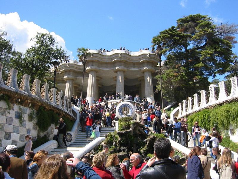
File:Parc Guell 01.jpg
Overcrowding in Parc Guell (Wikipedia Commons) 

Madrid

The city of Madrid is one of Europe’s major tourist destinations. In 2011 the city received little over 16.3 million guest nights from 8.3 million visitors. The number of Spanish and international tourists is about equal, with fewer international visitors than Barcelona but more domestic visitors. Tourism is also more equitably spread over the year, with the occupancy rate of hotels being roughly the same over the year, whereas in Barcelona it is high in the summer months and low in winter (Gladen/Bacon 2012). Tourism in Madrid is mainly concentrated in the historic city centre, and particularly the art museums such as the Prado in the south east. However, there are no signs so far that pressure by tourism has reached levels similar to Barcelona.

An article by Valenzuela and Hidalgo (2010), based on interviews with different stakeholders concerning tourism in Madrid historic city centre, seems to show no great concern over the pressures of tourism on the liveability of the neighbourhood. There is overall consensus that heavy car and bus traffic caused by tourism should be banned and the centre should be pedestrianised further, but nobody seems to suggest restrictive measures banning tourist activities. Most stakeholders do not really see the need for spreading the cultural attractions more evenly over the city. What is emphasised is the need to maintain other economic activities traditionally located in the centre. Tourism is not such a threat to these activities in the face of other global economic changes.

The famous Prado art museum

The city centres of Barcelona and Madrid are both foci of tourism, and are similar sizes and population densities. Despite similar numbers of tourists, Madrid seems to have fewer problems of overcrowding. This can be easily, if superficially, analysed by looking at the number of visitors to “top attractions”: in Madrid, the Prado museum receives around 2.7 million visitors a year, and Reina Sofia around 2.1 million (wikipedia). In Barcelona, Sagrada Familia receives over 3 million visitors a year (not including the ones who stand outside just to take photos), whilst Parc Guell receives an incredible 9 million (or 3,000 per hour). Such intensity has prompted Barcelona’s authorities to charge entry to the public park.

This highlights what may be different cultures of tourism in the two cities. Barcelona has a well-defined hierarchy of “sights to see”, creating strong overcrowding in key areas. It has a much more prominent international reputation for sightseeing and partying than Madrid, activities that are problematic if highly concentrated. Madrid’s most famous and most visited attractions are musea, where crowd control is easier and visitors remain mostly within the building. In addition, a higher proportion of Madrid’s visitors are domestic, which could lessen local feelings of alienation. We can therefore postulate that Madrid’s style of tourism is more socially, environmentally and economically sustainable: visitors are more dispersed and therefore less visible, allowing local economies, character and customs to thrive alongside international tourism. In Barcelona, action will have to be taken quickly in order to lessen antagonism between locals and tourists, and safeguard the ambience and characteristics that make Barcelona a pleasant place to live and attract tourists there in the first place.


References

The Sad Demise of a Brummie Icon

Central-Library-demolition-2
Demolition – January 2016. From the Birmingham Mail

For the past year Birmingham’s divisive Brutalist Central Library has been silent and dark, its tattered exterior netting fluttering in the wind.  Its high-tech replacement (Birmingham’s fourth Central Library since the 1890s) opened in 2013, standing a few hundred metres away on Centenary Square.

The fate  of the Brutalist  Central Library was sealed after an application by the City Council to grant it immunity from gaining listed status – and thus giving it protection from demolition – was granted by the Secretary of State in 2011. This immunity would have run out on 10th January 2016. And so despite two listing applications from English Heritage, protests from notable architecture and civic groups, and a warning from the World Monuments Forum, demolition began in December 2015.

It is a sorry end to a titan of Birmingham’s cityscape. The Library is a huge part of Birmingham’s post-war architectural heritage, and one of the most important Brutalist buildings in the country. Back in 2014 I wrote an article for Failed Architecture, contemplating the history and symbolism of the building. As the diggers gnaw away at its bold inverted ziggurat, we should remind ourselves of what Birmingham could be losing.

As to Birmingham’s buildings, there is little of real worth in our architecture. Its replacement should be an improvement… As for future generations, I think they will be better occupied in applying their thoughts and energies to forging ahead, rather than looking backward – Sir Herbert Manzoni, Birmingham’s chief City Engineer from 1935 to 1963

‘Forward’. A single word, emblazoned at the foot of Birmingham’s coat of arms. Few mottos could better capture the mentality of Britain’s second largest city. Arguably no other place in the UK has been so relentless in seeking to erase the past and reinvent itself every few decades. And few places better exhibit this contradictory tendency, at once both hopeful and myopic, than Birmingham’s 1970s Central Library – loved and hated in equal measure, and now facing demolition at the end of the year. 

IMG_6713
The famous inverted Ziggurat, butting against the city’s art gallery

Read more here –

Paradise Lost: Birmingham’s Central Library and the Battle over Brutalism

The Planning Statement

Planning Statements are the bread and butter of the Planning Consultant; the credo for the profession; and one of the single most involved parts of the job. And yet, when you scan the list of documents on the Local Council checklist outlining what must be submitted with a planning application, you won’t find the planning statement. It is not a statutory requirement, and clients are under no obligation to have them written. Why, then, do we bother?

Planning Statements will not always be necessary. Most planning applications, whether to change windows on an old building or cut down a tree, are too small to need one. But for any larger proposals – particularly those that are out of the ordinary – a planning statement will provide a useful summary of what the proposal is, how it accords with planning policies, and why the Local Authority should grant it permission. It summarises the whole application in one useful, readable and comprehensive document, and will be the first point of call for anyone wanting to respond to your application: from councillors, to consultees such as County Highways and environmentalists, to angry neighbours.

In order to be of any use, the Planning Statement should include some key information.

  1. Introduction

Fairly self-evident: what is this statement for, and what does it cover?

  1. The Application Site

This should:

  • Describe the current use of the site
  • Describe its location in relation to local settlements, transport, and immediate surroundings.
  • Give an outline of its planning history – are there any historic planning applications for this site that are of relevance to the current proposals?
  1. The Application

This is one of the fundamental sections, and what most readers will be looking for.

Firstly, it should cover the procedural issues, aiming to describe the proposals in as much excruciating detail as possible.

  • Layout of the development – obviously important if there is more than one building. What is road access like? Are there key frontages, any landmark buildings? What is the pedestrian and cycling permeability?
  • Design: this covers massing; scale; style; materials;  context/local vocabulary; appearance
  • Access: how is the development connected to the local road network; is there any available public transport; how much car and cycle parking will there be, and why?
  • Landscaping – hopefully the scheme will be nice and green

Then you move to the technical issues, which cover matters that are particular to the site. Every site has its own constraints or peculiarities: flooding, heritage, landscape impact, environmental importance, land contamination… Each issue will require its own specialist report from external consultants, and in this part of the Planning Statement their findings and conclusions should be summarised. It doesn’t have to have a particular order, but should be logical. It should also cover any pre-application advice received from the Council, and whether any neighbours were consulted.

  1. Planning Policy

This is where you really sell the development. Section 4 should outline exactly how it complies with all the relevant planning policies, and why it really is the best thing to happen to the local authority since getting a Waitrose. In making a decision, the Planning Committee will be looking at how the development complies with their vision and planning policies for the area. Adding in a section on this exact matter therefore does their job for them.

Firstly, you should present the context and describe the documents that are relevant to the site, in order of importance.

  • The Development Plan of the local Council, which normally includes a Local Plan and/or Core Strategy, Development Management Policies, and Proposals Maps;
  • Any supplementary planning documents that might deal with the use or location of the proposal (for instance, local masterplans, or policy documents governing town centre developments)
  • The National Planning Policy Framework (NPPF), the key national policy document

You then take each document in turn, pick out the policies that are most relevant to your proposal, and how your proposal complies with this policy. For instance:

Policy CS18 of the Core Strategy states that proposals for residential development should maintain or create a sense of place and character. As noted above, the application scheme seeks to respond to the rhythm, scale and massing of existing development fronting Essex Road. This will enhance Essex Road’s street scene and its “sense of place”.

  1. Sustainability

Whilst it won’t always be necessary, this is a useful section to include. Since the publication of the NPPF in 2012, sustainability has become a key consideration in planning decisions. The NPPF states in paragraph 6 that “The purpose of the planning system is to contribute to the achievement of sustainable development”, and that any development that can prove it is sustainable should be approved “without delay”. How, then, does this development contribute towards the economic, environmental and social aspects of sustainability outlined in the NPPF?

  1. Benefits

This is another useful section, which could act as a summary for anyone who doesn’t have time to read the whole document (which is probably 30 pages by now). This should summarise the key benefits of the proposal, to make it absolutely clear that any negatives are massively outweighed by the positives. If you don’t make a sales pitch for it, then no one else will.

  1. Conclusion

The conclusion should broadly say:

This statement has demonstrated that the proposal accords with planning policy; it is sustainable; and it will provide many different benefits. We therefore respectfully ask the Council to grant planning permission.

What next?

The Planning Statement, along with the application forms, architectural drawings, certificates of land ownership and any technical reports, will then be submitted as a single Planning Application to the Local Authority. It will be assigned to a Planning Officer, a trained planner working in the Council, who will send it on to any consultees (such as County Highways, the Environment Officer, English Heritage, local emergency services and neighbours) who have the chance to comment on the proposals. Based on the feedback of the consultees and their own judgement of how well the proposal complies with policy, the Officer writes a report that will recommend the application for permission or refusal. This will then be sent to the Planning Committee, the elected body of Councillors who will ultimately determine whether to follow the Officer’s recommendation.